The salt air doesn't just sit on your skin in the West Philippine Sea; it bites. It carries the scent of diesel, fermented fish, and the heavy, humid weight of a storm that refuses to break. For the fishermen of Palawan or Zambales, the ocean is not a map of geopolitical chess pieces. It is a kitchen. It is a graveyard. It is the only bank account they have ever known.
But lately, the horizon looks different. It isn't just the white hulls of the China Coast Guard or the rusted steel of maritime militia boats. Now, there are the ghosts. High-tech, silent, and draped in the clinical legitimacy of "marine scientific research," these vessels represent a new kind of intrusion. They don't carry guns—at least, not visibly. They carry sensors. They carry winches. They carry the power to map the very ground beneath a nation’s feet without ever asking for a key.
When the Philippine government recently issued a sharp warning to a Chinese research vessel detected loitering within its Exclusive Economic Zone (EEZ), the headlines read like a dry bureaucratic spat. To the world, it was a footnote in a long-running territorial dispute. To the people whose lives depend on those waters, it was something much more intimate. It was a trespasser in the basement.
The Invisible Map
Imagine you own a house. You know where the walls are, and you know where the garden ends. One morning, you look out the window and see a stranger in your backyard with a high-end ground-penetrating radar. They aren't stealing your lawn furniture. They aren't kicking your dog. They are simply mapping the foundations of your home. They are finding the weak spots in your concrete, the location of your water pipes, and the exact depth of your cellar.
When you ask them to leave, they smile and tell you they are doing "geological soul-searching" for the good of humanity.
This is the reality of modern maritime friction. The vessel in question, often part of a fleet of Chinese state-affiliated research ships like the Shen Kuo or the Xiang Yang Hong series, isn't just looking at colorful fish. These ships are equipped with multi-beam echo sounders and seismic survey tools. They are building a digital twin of the ocean floor.
Why does that matter to a guy in a wooden banca boat? Because knowledge is the precursor to extraction. You cannot drill for oil you haven't found. You cannot lay the acoustic arrays for submarine warfare if you don't understand the thermal layers and the jagged canyons of the seabed.
The Philippines, a nation of over 7,000 islands, finds itself in a position where its borders are being digitized by a neighbor that doesn't recognize those borders. Manila's warning wasn't just about a boat being in the wrong place. It was a desperate attempt to assert ownership over information itself.
The Weight of a Warning
Manila’s rhetoric has shifted. Under the current administration, the "gray zone" tactics of the past—where intrusions were met with quiet diplomatic notes that disappeared into the void—have been replaced by a policy of transparency. They are shouting from the rooftops now.
But shouting into a gale is exhausting.
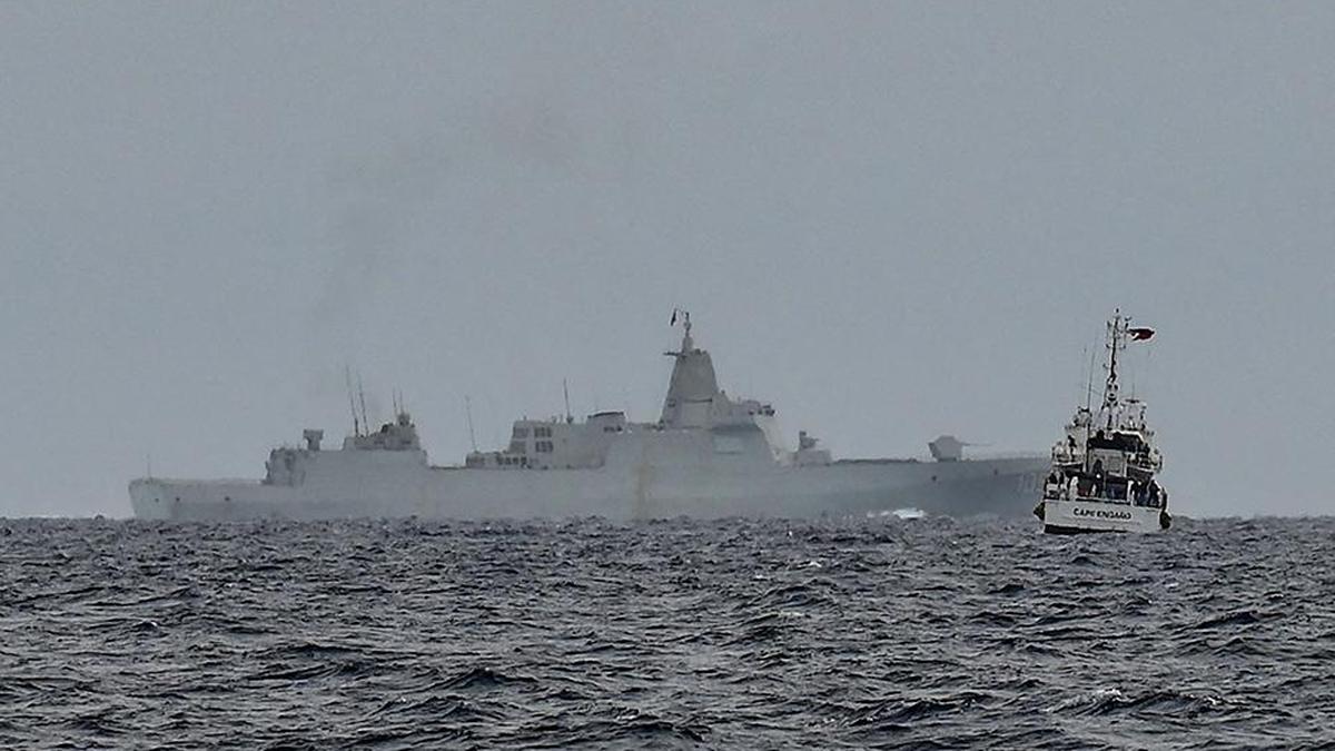
The Philippine Coast Guard is a collection of brave souls operating on a budget that wouldn't cover the paint job on a single Chinese destroyer. When they issue a radio challenge to a research ship, they are met with a pre-recorded script. The voice on the other end of the radio is often calm, clinical, and utterly dismissive. It claims "innocent passage" or "scientific necessity."
Consider the hypothetical case of a young ensign on a Philippine patrol craft. Let's call him Mateo. Mateo stands on a deck that vibrates with the effort of keeping pace with a much larger, modern Chinese ship. He looks through his binoculars and sees a forest of antennas. He knows that his boat is being tracked by satellites, painted by radar, and perhaps even listened to by underwater hydrophones.
Mateo’s job is to say, "You are in our waters. Please leave."
The silence that follows isn't empty. It is heavy with the implication that his words don't matter because the ship he is hailing represents a power that views the entire sea as its rightful pond. The frustration isn't just professional; it’s existential. It’s the feeling of someone standing in your living room and refusing to acknowledge that you are even there.
The Science of Sovereignty
There is a certain irony in using "science" as a shield for expansionism. True scientific cooperation is the bedrock of ocean health. We need to understand the warming of the seas, the migration of tuna, and the health of the coral reefs that feed millions.
But science in the South China Sea has become weaponized.
When a research vessel drops a buoy, that buoy isn't just measuring salinity. It is a sensor in a vast, interconnected network that helps Beijing track every movement in the region. This is the "Blue National Territory" strategy. By physically being there—mapping, measuring, and naming underwater features—China creates a "historical record" of presence.
If you name a seamount, you claim a memory of it. If you map it, you own its secrets.
The Philippines is fighting a lopsided battle against this data-driven encroachment. While Manila focuses on the legalities of the 2016 Hague ruling—which explicitly stated that China has no legal basis for its "nine-dash line"—Beijing focuses on the physical reality of the waves.
The law says the water belongs to the Philippines. The sensors say the water is being mastered by China.
The Silent Creep
The danger of these research ships is that they don't look like an invasion. There are no missiles. There are no troop transports. It is a slow, methodical, and incredibly expensive form of "scientific" squatting.
It starts with a survey. A few months later, a "weather station" appears on a nearby reef. A year later, that reef has been dredged into an island with a runway.
The warning issued by Manila is an attempt to break that cycle before it reaches the point of no return. It is a signal to the international community that the "theft" taking place isn't just of territory, but of the future.
For the Filipino people, the stakes are found in the price of galunggong (round scad) at the local market. As foreign vessels push further into Philippine waters, local fishermen are forced into smaller, overfished areas. Their yields drop. Prices rise. A geopolitical dispute in the high seas becomes a hungry belly in a Manila slum.
The technology used by these research ships is, in itself, a marvel.
The ability to peer through miles of dark water to see the jagged peaks of the sea floor is a testament to human ingenuity. But when that ingenuity is used to circumvent the sovereignty of a smaller nation, it ceases to be a tool of discovery. It becomes a tool of siege.
The Echo of the Radio Call
The Philippine Coast Guard continues its "naming and shaming" campaign. They post the photos. They release the radio transcripts. They show the world the gray hulls lurking in the blue water.
It is a brave strategy, but a fragile one. It relies on the world caring. It relies on the idea that international law is more than just ink on a page.
The real struggle isn't happening in a courtroom in The Hague or a summit in Brussels. It is happening in the static of a radio transmission at 3:00 AM, somewhere off the coast of Palawan. It is the sound of a small voice telling a giant to move, and the giant pretending not to hear.
The ocean has a way of swallowing sounds. Every warning, every protest, and every plea for respect can feel like it’s being lost in the vast, churning indifference of the Pacific.
But silence isn't an option. To stop protesting is to admit that the map has already been redrawn. To stop shouting is to accept that the stranger in the basement now owns the house.
The ship stays. The sensors hum. The water remains restless.
The ocean floor is being mapped, inch by agonizing inch, and with every data point recorded, the distance between the law and the reality grows wider. The ghosts in the Sulu Sea are not going away. They are simply waiting for the world to stop looking.
One day, we may wake up to find that the sea we thought we knew has been replaced by a version that only one side has the coordinates to navigate.
The salt still bites. The diesel still hangs in the air. And somewhere out there, a small boat is still waiting for an answer that may never come.


