The rules of engagement in the Middle East just hit a reset button. For decades, the shadow war between Israel, the United States, and Iran played out in the dark, defined by cyberattacks and assassinations that everyone knew happened but nobody officially claimed. That era is over. Recent verified imagery from targeted sites across Iran shows a shift from "deniable" harassment to high-precision surgical dismantling of Iranian military infrastructure.
If you've been following the headlines, you've seen the smoke. But if you look at the high-resolution satellite passes from firms like Maxar and Planet Labs, you see the strategy. It's not about carpet bombing or regime change. It's about a cold, calculated neutralization of specific capabilities—specifically drone production and missile defense—that makes the old "tit-for-tat" look like child's play.
Why precision matters more than power
When we talk about bombardments in Iran, people often imagine massive explosions leveling city blocks. The reality on the ground is far more interesting. Verified images of the Parchin and Khojir military complexes show something remarkable. Instead of entire facilities being wiped out, specific buildings—often those housing industrial mixers for solid rocket fuel—were turned into rubble while the structures next door remained untouched.
This isn't just "good aiming." It's a loud message. By hitting the "bottleneck" components of Iran's ballistic missile program, the U.S. and Israeli intelligence communities are proving they know exactly how the Iranian war machine is built. They aren't just attacking; they're auditing. If you destroy a warehouse, they can rebuild it in a month. If you destroy the rare, specialized machinery used to mix fuel for long-range missiles, you've set their program back by years.
I’ve looked at these strike patterns, and they don't look like a standard air campaign. They look like a scalpel. You don't need a thousand planes when you have the exact GPS coordinates of a single specialized vent or a specific power substation.
The end of Iranian air defense superiority
One of the biggest takeaways from the latest round of verified imagery is the systematic failure—or perhaps the intentional bypass—of Iran’s S-300 surface-to-air missile systems. For years, Tehran touted these Russian-made systems as an impenetrable shield.
The photos tell a different story.
Open-source intelligence (OSINT) analysts have identified charred remains of S-300 radar arrays near Tehran and at critical energy hubs. What’s wild is that the radars were hit while they were active. This suggests a level of electronic warfare and stealth capability that essentially makes Iran’s primary defense layer transparent. When the radar is gone, the "eyes" of the military are poked out. Once that happens, the rest of the facility is a sitting duck.
We are seeing a new reality where Iran's conventional defenses are effectively obsolete against the current generation of Western and Israeli standoff weapons. It’s a terrifying prospect for any military commander to realize that your most expensive hardware can be picked off before it even tracks an incoming threat.
The drone factories are the new front line
Iran's greatest export over the last few years hasn't been oil; it's been the Shahed drone. These "suicide" drones have reshaped conflicts from Ukraine to the Red Sea. Naturally, they’ve become the primary target of recent strikes.
Satellite images of sites like the Shahroud space center and various IRGC industrial parks show a heavy focus on the logistics of drone assembly. It’s a smart move. By targeting the points where components from abroad are integrated into the airframes, the attackers are strangling the supply chain.
People often ask why these strikes don't stop the drones entirely. The truth is, you can't stop a technology that can be built in a garage. But you can stop the industrialization of that technology. You can prevent them from making 500 a month and force them back down to 50. That’s the "inédite" or "unprecedented" part of this strategy—it’s an economic and industrial war disguised as a kinetic one.
Misconceptions about civilian impact
There’s a common narrative that these strikes are hitting civilian centers. The verified imagery actually contradicts this. Because the munitions used are so precise—think the R9X or specialized GPS-guided "small diameter bombs"—the "splash damage" is incredibly low.
- Fact: Most targets are located in mountainous or desert regions far from urban cores.
- Fact: Strike timing often occurs late at night to minimize personnel casualties while maximizing equipment destruction.
- Observation: The goal appears to be "disarmament through destruction" rather than "victory through body counts."
The geopolitical fallout of being seen
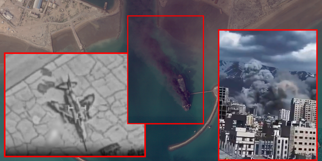
The most significant change isn't the damage itself. It’s the fact that we can see it. In 2010, the Stuxnet virus crippled Iranian centrifuges, and it took months for the world to realize what happened. Today, within two hours of a strike, a commercial satellite is overhead, and an analyst in London or Washington is tweeting a high-res "before and after" shot.
This transparency changes the diplomatic game. Iran can no longer downplay the damage to its domestic audience. When the world can see a hole in the roof of your "impregnable" missile base, the "strongman" image starts to crack. It forces a choice: escalate and risk more visible failure, or swallow the loss and try to rebuild in secret.
Honestly, the satellite imagery is basically a public humiliation tool now. It’s one thing to be hit; it’s another for the entire planet to see exactly how vulnerable you are in 4K resolution.
How to track these developments yourself
You don't need to be a CIA analyst to stay ahead of this. The democratization of satellite data means the information is out there if you know where to look. If you want to see the "strategy" for yourself, you have to look past the social media clips of fireballs.
Start by following OSINT accounts that focus on "SAR" (Synthetic Aperture Radar) imagery. Unlike standard photos, SAR can see through clouds and smoke. This is how we knew the extent of the damage at the Isfahan airbase even when there was heavy cover. Check the work of analysts who use "change detection" software—it highlights exactly which pixels have changed between two satellite passes, revealing hidden damage that a human eye might miss.
Pay attention to the specific types of buildings being targeted. If the buildings are "hardened" (reinforced with thick concrete or buried underground) and they are still being destroyed, it tells you the attackers are using advanced "bunker-buster" tech. This is a clear signal that no site in Iran, no matter how deep, is truly safe.
The next time you see a report about a strike, don't just read the headline. Look for the coordinates. Pull them up on a map. Look at what is around the site. Usually, you’ll find a high-voltage power line or a specialized rail spur. That’s the real target. The strategy is to turn Iran’s military into a collection of isolated islands that can’t talk to each other, can’t power their weapons, and can’t resupply their front lines.
The era of "guessing" what happened in Iran is over. The eye in the sky has seen it all, and it’s telling us that the strategy of the West and Israel has shifted from containment to active, surgical degradation.